This research work aims to analyze hydrocarbon spills along the Ivorian coasts using geospatial techniques. The objective is to geolocate oil spills that occurred from 2018 to 2023 on the Ivorian coast using radar images. These images, available and downloadable from the Copernicus site, processed in ESA SNAP software, have made it possible to detect oil spills, thanks to their ability to distinguish contaminated surfaces from unpolluted water. The techniques used made it possible to carry out radiometric corrections and to remove the speckle noise, followed by the extraction of the spill zones from the differences in water reflectivity. The data processed have been validated thanks to the data from the Project Earth Observation for Sustainable Development (EO4SD)-Marine Resources. The results thus show significant concentrations of spills along the Ivorian coasts, especially in areas close to the oil infrastructures at-49dB in 2018, -48.9 dB in 2019,-57 dB in 2020, -48 dB in 2021,-46 dB in 2022,-48 dB in 2023. These values are low and reflect oil spills. They reduce the Radar backscatter coefficient because of their smoothing effect on the surface of the water. In addition, the spread of flowing hydrocarbons spilled to an east-west preferential direction that is to say from Assinie to Jacqueville. These results highlight the need to improve preventive measures and strengthen environmental policies to reduce the impacts of spills on marine ecosystems. This work opens the way to future research prospects, in particular the automation of the detection of oil spills using artificial intelligence models and the extension of the study to other regions of West Africa. This study is therefore a contribution to environmental monitoring and management of hydrocarbon pollution risks in Côte d'Ivoire.
This is an Open Access article, distributed under the terms of the Creative Commons Attribution 4.0 International License (http://creativecommons.org/licenses/by/4.0/), which permits unrestricted use, distribution and reproduction in any medium or format, provided the original work is properly cited.
Pollution of seas and oceans is a worrying fact due to the role of receptacle that these immense expanses of water play. This pollution affects the coastlines of the world and is in fact the work of several rejections, a large part of which emanates from the immersion of hydrocarbon residues in the oceans. The sources are multiple: oil accidents, illegal degassing of ships, leaks from land pipelines, industrial discharges, etc. During offshore farms, there are hydrocarbon spills that cause pollution of the marine environment and coastal areas, interface environments between land and sea ecosystems. Coastal pollution by hydrocarbons destroys natural habitats such as mangroves, sea herbaries, spawning grounds, by asphyxiating fish and destroying their eggs. About of animals, during hydrocarbon pollution, there is a rapid reduction in number and diversity of invertebrates. Associated bird sand predators undergo damage linked to direct contact or by ingestion of contaminated food. The impacts can be serious in the long term if oil residues are incorporated in to the sediment. In Côte d'Ivoire, pollution of the coastline by hydrocarbons is a chronic problem, especially near the oil installations of Abidjan, in particular between Jacqueville and Assinie. Indeed, the beaches of this coastal section are strewn with residues and hydrocarbon dumplings. There are often oily tablecloths that derive according to marine movements from the sea to the coast and illegal rejections of oil residues not treated in the Abidjan district. The same is true for the wragging of oil equipment which is one of the causes of the risk of pollution within the autonomous port of Abidjan
[1]
Ayenon, S., F., et Siaba, F., X., D. (2024). Risque de pollution lié au vieillissement des installations pétrolifères portuaires au Port Autonome d’Abidjan. GEOTROPE, Hors-Sérien°1, Avril 2024, ISSN 1817-5589, pp 46-58.
[1]
. This contamination is located at the berries, lagoons close to Abidjan and all Ivorian coastal waters whose tolerance threshold is 2μg/L chrystène equivalent. The impacts on fishing and tourism are inevitably important. The ecological and economic consequences of these spills are often disastrous, in particular for sensitive coastal ecosystems such as mangroves, coral reefs, sea herbaries and maritime borders. The insufficient data and the lack of real-time monitoring of hydrocarbon spills on the Ivorian coast are crucial problems to which the Direction Générale des Affaires Maritimes et Portuaires, local coastal communities, the private sector (Autonomous Port of Abidjan, oil companies), NGOs will have to face. Unfortunately to date, little data exists to efficiently follow accidental spills of petroleum products on the Ivorian coast. The contribution of remote sensing through the use of radar satellite imaging could fill this lack of data and provide precise responses to the sustainable management of accidental hydrocarbon spills on the Ivorian coasts. Indeed, in the marine field, the SAR system (Synthetic Aperture Radar) measures the Radar backscatter coefficient of the surface of the sea. This Radar backscatter coefficient depends on the roughness of the surface of the water, itself induced by the clapot under the action of the wind. The average clapot wavelength allows the radar wave to resonate and return the energy to the satellite. The roughness of the surface of the water is likely to vary as soon as a local disturbance, as for example by the presence of a body of viscosity different from that of free water, is present on the surface of the water. Thus, the presence of hydrocarbons on the surface of the water considerably reduces surface roughness
[2]
Johannessen, O., M., Sandven, M., Jenkins, A., D., Durand, D., Petterson, L., H., Espedal, H., Evensen, G., & Hamre, T. (2000). Satellite earth observation in operational oceanography. Coastal Engineering, 41, pp. 155-176.
[3]
Espedal & Johannessen (2020). Geophysical characterization of active thermogenic oil seeps in the salt province of thelower Congo basin part I: Detailed study of one oil-seeping site, Vol. 103, No. 5, 753-772p.
[4]
Williams, A. & Lawrence, G. (2002). The Role of Satellite Seep Detection in exploring the South Atlantic’s Ultra deepWater, in Surface exploration case histories: Applications of geochemistry, magnetic, and remote sensing, Shumacher, D.,& Le Schack, L. A., eds., AAPG Studies in geology No. 48 and SEG Geophysical References Series No. 11, 327-344.
[5]
Zatyagalova, V., V., Ivanov, A., Y., & Gobulov, B., N. (2007). Application of Envisat SAR imagery for mapping and estimation of natural oil seeps in the South Caspian Sea.
[6]
Ivanov, A., Y., Gobulov, B., N., & Zatyagalova, B., B. (2007). On oil and gas seep sand underground fluid discharges in the Southern Caspian based on Space Radar Data. Earth Exploration from Space, 2, 62-81.
[7]
Garcia-Pineda, O., Zimmer, B., Howard, M., Pichel, P., Li, X., Mac Donald, I., R. (2009). Using SAR images to delineate ocean oil slicks with a texture-classifying neural network algorithm (TCNNA). Canadian journal of Remote Sensing, 35,411-421.
[8]
Korber, J., H., Sahling, H., Pape, T., Dos Santos Ferreira, C., Macdonald, I., & Bohrmann, G. (2014). Natural oil seepage at Kobuleti Ridge, eastern Black Sea. Marine and Petroleum Geology, 50, pp. 68-82.
[2-8]
. No energy is returned to the satellite in the presence of hydrocarbons, it then appears as a task with low Radar backscatter coefficient on the SAR images, displayed in black by convention. The identification of natural layers is directly dependent on the difference in surface roughness between water not covered by oil, called" free" water and water covered with hydrocarbons.
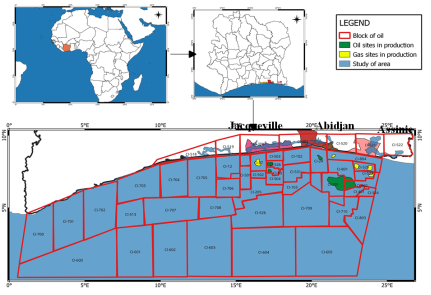
Location of the study area
The study area covers 80 km along the southeast coast of Côte d'Ivoire, bordered by the Atlantic Ocean in the South. This region is based on the Ivorian coastal sedimentary basin, mainly composed of quaternary and neogenic sediments. The basement consists of alluvial and sailors deposits formed by the accumulation of sands, clay sand gravel. These sediments are the result of erosion, transport and deposit processes from rivers such as the Comoé River, as well as the action of sea current sand tides. The lagoons and wetlands along the coast are ecologically sensitive habitats and play a crucial role in water regulation and flood protection. In short, the region has a complex geological environment, influenced by coastal and sedimentary factors. Geological constraints, such as coastal erosion, subsidence, and vulnerability to floods, must be taken into account for sustainable development in the region. Figure 1 presents the geographical location of the study area.
Figure 1. Geographical location of the study area.
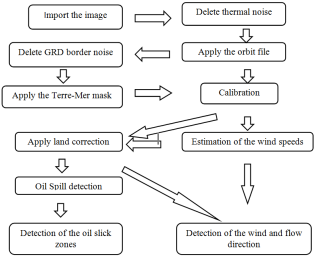
2. Data Acquisition and Methodology
The data used are mainly composed of Sentinel-1 A satellite images from 2018 to 2023, available and downloadable from the following linkhttps://scihub.copernicus.eu/dhus/#/home. ESA SNAP andQGIS softwares has been used respectively for data processing and cartographic layout of the data. This digital treatment method in SNAP software was carried out by carrying out several pre-treatment steps in SNAP below: a) subset (subset extraction) which aims to reduce the size of the data by extracting the specific area of interest, b) Calibration converted the radar intensity values in to significant physical values, such as Radar retro Specific quantitative analysis, c) Filter (Denoising) reduces the speckle noise present in radar images to improve the visual quality and the precision of the detection, d) Correction field (corrected geometric distortions) caused by the topography and geometry of the sensor, and project the image on a reference card, e) Oil Spill Detection use specific algorithms to identify and extract potential oil spills areas from the radar image. In addition, the digital processing of images also made it possible to determine the direction of the spread of fluids obtained from radar images. Indeed, the use of wind data has simulated the trajectory of the oil slicks in the waters. A specific processing method has therefore consisted in eliminating thermal noise by application of specific filters (LEE or Frost filter) available in SNAP, as well as GRD border noise (Ground Range Deteted) making it possible to clean the image of unwanted artefacts which often appear along the edges of SAR images. Then, the application of a Land-sea mask, the calibration of the data in order to convert the raw values radar in to measurable physical Radar backscatter coefficient values (σ⁰) made it possible to determine the direction and the wind speeds on the surface of the sea.
3. Validation of Data
The data processed have been validated thanks to the data from the Project: Earth Observation for Sustainable Development (EO4SD)-Marine Resources (http://eo4sd-marine.eu). A report on oil spill detection using Sentinel-1 SAR sensor EO data.
Figure 2. Organizational chart of the methodology used.
4. Results
4.1. Detection of Oil Spills in Sea Waters
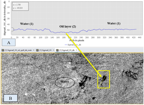
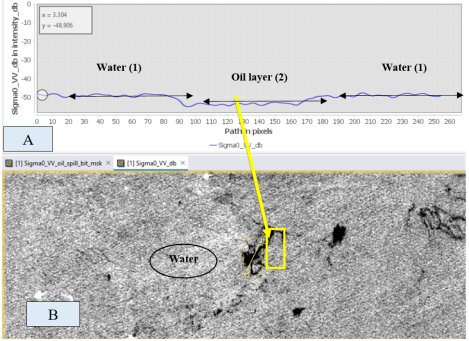
The results show that the fluids detected on the images are water and oil layers. The dark areas on the images (yellow colors on the figures) translate areas with lower radar reflectivity, associated with smooth surfaces such as oil slick on sea waters. This indicates water surfaces without major abnormality. The significant reductions in the values of reflectivity are typical of oil layers, reducing the Radar backscatter coefficient because of its smoothing effect on the surface of the water.
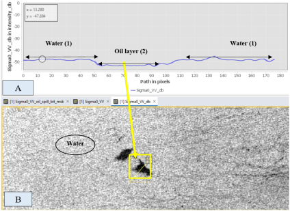
4.1.1. Oil Spills in 2018
In 2018, the radar signal varying between pixels 140 and 230 was observed, which seems to be a radar image in gray levels, with marked contrasts between the clear and dark areas. The areas labeled "Water (1)" show slightly fluctuating but relatively stable radar reflectivity values (between-15 dB and-20 dB). The area marked "Oil layers (2)"shows a marked decrease in reflectivity, reaching very low values of-49 dB. Figure 3 presents the spatial distribution of oil slicks in the sea waters from Jacqueville to Assinie in 2018.
Figure 3. Spatial distribution of oil slicks in the sea waters from Jacqueville to Assinie in 2018.
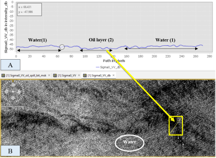
4.1.2. Oil Spills in 2019
In 2019, the signal intensity showed pixel declines ranging from 100 to 160 pixels. The "water" layer has radar reflectivity values from -15 dB to-20 dB. As for the "oil layer", it shows a sharp decrease in reflectivity, reaching-48.9dB. Figure 4 presents the spatial distribution of oil slicks in the seawaters from Jacqueville to Assinie in 2019.
Figure 4. Spatial distribution of oil slicks in the sea waters from Jacqueville to Assinie in2019.
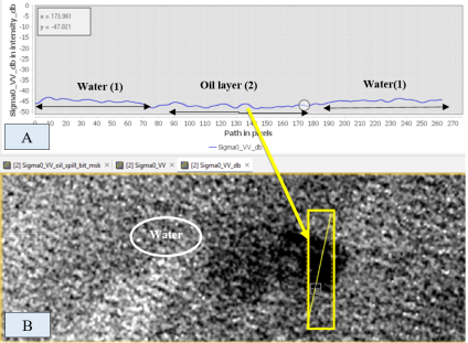
4.1.3. Oil Spills in 2020
In 2020, a very low of variation intensity, with pixels from 60 to 90 was observed. The areas labeled «Water (1)" show slightly fluctuating but relatively stable radar reflectivity values from -10 dB to -15 dB while the "oil layer (2)"presents low values of-57 dB. Figure 5 presents the spatial distribution of oil slicks in the sea waters from Jacqueville to Assinie in 2020.
Figure 5. Spatial distribution of oil slicks in the sea waters from Jacqueville to Assinie in2020.
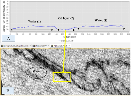
4.1.4. Oil Spills in 2021
In 2021, the pixels continued to decrease and are between 100 and 140 pixels with a "water" layer showing radar reflectivity values from-10 dB to -15 dB and" oil layer" displaying low values of-48 dB. Figure 6 presents the spatial distribution of oil slicks in the sea waters from Jacqueville to Assinie in 2021.
Figure 6. Spatial distribution of oil slicks in the sea waters from Jacqueville to Assinie in2021.
4.1.5. Oil Spills in 2022
In 2022, decreases of pixels varying between 100 and 180 made it possible to detect a "water" layer with radar reflectivity values varying from -10 dB to -20 dB. The layer of oil indicates a marked decrease in reflectivity, reaching low values of -46 dB. Figure 7 presents the spatial distribution of oil slicks in the sea waters from Jacqueville to Assinie in 2022.
Figure 7. Spatial distribution of oil slicks in the sea waters from Jacqueville to Assinie in 2022.
4.1.6. Oil Spills in 2023
In 2023, the radar signal to pixels varying between 150 to 180 made it possible to detect the water layer varying between-10 dB and -20 dB. As for the oil layer, it shows a decrease in reflectivity reaching the values of -48 dB. Figure 8 presents the spatial distribution of oil slicks in the seawaters from Jacqueville to Assinie in 2023.
Figure 8. Spatial distribution of oil slicks in the sea waters from Jacqueville to Assinie in 2023.
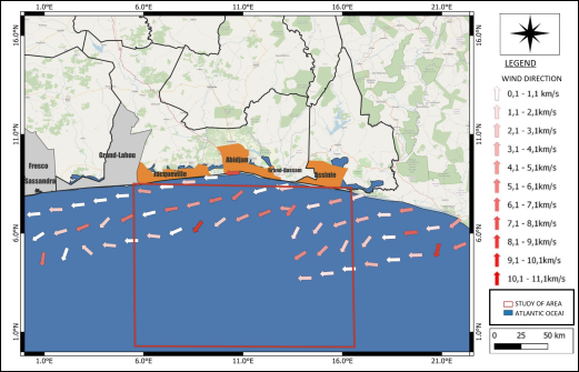
4.2. Detection of the Flow Direction of the Oil Spills
Data analyzes made it possible to identify the flow of oil spilled. Indeed, the wind speeds that blow in the study area are low and vary between 0.1 and 11.1 km/s. They have a preferential direction East-West, from Assinie to Jacqueville. Figure 9 presents the flow direction of oil spilled in the study area.
Figure 9. Flow direction of oil spilled in the study area.
Discussion
Many studies have explored the potential of the polarization of sensors for the detection of oil spills layers
[9]
Elachi C. (1988)."Space borne Radar Remote Sensing: Applications and Techniques. "IEEE press, ISBN0879422416 (1988): 288.
[10]
Robinson, I., S. (1994)."Satellite oceanography. An introduction for oceanographers and remote sensing scientists. "Wiley-Praxis series in remote sensing (1994): 455.
[11]
Fortuny-Guasch J. (2003)."Improved oil spill detection and classification with polarimetric SAR."Proc. workshop on Application of SAR Polarimery and Polarimetric Interferometry, ESA-ESRIN Frascati, Italy (2003): 14-16.
[12]
Jackson, C., R., & Apel, J., R. (2004). A Simulation of Reflected ADS-B Signals over the North Atlantic for a Space borne Receiver, 464p.
[13]
Najoui, Z., Riazanoff, S., Deffontaines, B., and Xavier, J.-P. (2018): Estimated location of the sea floor sources of marine natural oil seeps from sea surface out breaks: A new “source path procedure ”applied to the northern Gulf of Mexico. Mar. Petrol. Geol., 91, 190 201,
and emphasize that cross polarization (VH, HV) is considerably less effective than co-polarization (VV, HH). This is confirmed in our study because the use of VV polarization made it possible to precisely detect the oil slicks. Our significant contribution lies in the establishment of IW mode, coupled with VV polarization, as the most efficient combination for the detection of oil slicks under high wind conditions, thus offering an optimized approach for monitoring and detection in difficult environments. In addition, the influence of wind speed on the detectability of oil slicks on sea surfaces from radar images is a subject in which many research studies has been interested
[14]
Fingas, M., & Brown, C. (2014). Review of oil spill remote sensing. Marine pollution bulletin, 83(1), 9-23.
. These have used purely empirical approaches applied to cases of marine oil accidents, the nature of which is very special. In our case, 7 satellites images were analyzed in order to optimize detectability when wind speed is between 0.1 and 1 1.1 m/s. Beyond these conditions, there is little chance (5%) to detect an oil slicks. This interval clearly slices with those already announced which we quote: 3 to 7-10 m/s
[15]
Brekke & Solberg (2017). Utilisation d'un algorithme génétique pour la détection automatique des marées noires à partir des données du satellite SAR RADARSAT-2,112p.
[15]
, 3.5 to 7 m/s, 1.5-10 m/s, and 1at 7°M/S
[16]
Marghany M. (2014a)."Utilization of a genetic algorithm for the automatic detection of oil spill from RADARSAT-2 SARsatellite data. "Marine pollution bulletin 89.1 (2014): 20-29.
[16]
. It should be noted that our approach to fix an optimal wind speed for the detection of oil slicks aims to be global and representative of the type sand oil slicks, seasonality, geographic contexts, etc. Punctual measures and empirical studies are unable to meet our research needs at least. Clearly, the limit of this study lies in the distinction between natural oil seeps and oil spills from platforms or flower-like structures. In general, ships that discharge oily effluents do it on route, leaving linear-shaped spills or trails in their wake
[17]
Najoui, Z., Amoussou, N., Riazanoff, S., Aurel, G., and Frappart, F. (2022). Oil slicks in the Gulf of Guinea-10 years of Envisat Advanced Synthetic Aperture Radar observations. Earth Syst. Sci. Data, 14, 4569-4588, 2022.
. The stochastic approach is therefore the most suitable for fixed goals. Still with a view to a better understanding of the influence of wind speeds on the detectability of oil slicks, we have made a statistical normalization of the distribution of wind speeds to achieve another result, namely wind speeds between 2.09 and 8.33 m/s.
5. Conclusion
The analysis of radar data over the period from 2018 to 2023 made it possible to detect and map oil spills along the coast between Jacqueville and Assinie. Each year, distinct variations in radar reflectivity have revealed the presence of oil slicks by a significant decrease in the radar signal, typical of smooth surfaces such as oil slicks. The results show a continuous trend of oil spills in the six years studied, with specific areas where the intensity of reflectivity has decreased, indicating areas affected by oil spills. This cartography makes it possible to visualize not only the location of spills but also their evolution overtime, providing crucial information for environmental risk management on this part of the Ivorian coast. The use of artificial intelligence techniques, such as deep learning, could refine the methods of detecting oil slicks with best precision, with a view to fine and continuous long-term monitoring.
Abbreviations
SAR
Synthetic Aperture Radar
NGOs
Non-Gouvernmental Organization
ESA
European Space Agency
SNAP
Sentinel Application Platform
GRD
Ground Range Deteted
EO
Earth Observation
Author Contributions
Jacques André Tiémélé: Conceptualization, Data curation, Formal Analysis, Funding acquisition, Investigation, Methodology, Project administration, Resources, Software, Supervision, Validation, Visualization, Writing – original draft, Writing – review & editing
Ayenon, S., F., et Siaba, F., X., D. (2024). Risque de pollution lié au vieillissement des installations pétrolifères portuaires au Port Autonome d’Abidjan. GEOTROPE, Hors-Sérien°1, Avril 2024, ISSN 1817-5589, pp 46-58.
[2]
Johannessen, O., M., Sandven, M., Jenkins, A., D., Durand, D., Petterson, L., H., Espedal, H., Evensen, G., & Hamre, T. (2000). Satellite earth observation in operational oceanography. Coastal Engineering, 41, pp. 155-176.
[3]
Espedal & Johannessen (2020). Geophysical characterization of active thermogenic oil seeps in the salt province of thelower Congo basin part I: Detailed study of one oil-seeping site, Vol. 103, No. 5, 753-772p.
[4]
Williams, A. & Lawrence, G. (2002). The Role of Satellite Seep Detection in exploring the South Atlantic’s Ultra deepWater, in Surface exploration case histories: Applications of geochemistry, magnetic, and remote sensing, Shumacher, D.,& Le Schack, L. A., eds., AAPG Studies in geology No. 48 and SEG Geophysical References Series No. 11, 327-344.
[5]
Zatyagalova, V., V., Ivanov, A., Y., & Gobulov, B., N. (2007). Application of Envisat SAR imagery for mapping and estimation of natural oil seeps in the South Caspian Sea.
[6]
Ivanov, A., Y., Gobulov, B., N., & Zatyagalova, B., B. (2007). On oil and gas seep sand underground fluid discharges in the Southern Caspian based on Space Radar Data. Earth Exploration from Space, 2, 62-81.
[7]
Garcia-Pineda, O., Zimmer, B., Howard, M., Pichel, P., Li, X., Mac Donald, I., R. (2009). Using SAR images to delineate ocean oil slicks with a texture-classifying neural network algorithm (TCNNA). Canadian journal of Remote Sensing, 35,411-421.
[8]
Korber, J., H., Sahling, H., Pape, T., Dos Santos Ferreira, C., Macdonald, I., & Bohrmann, G. (2014). Natural oil seepage at Kobuleti Ridge, eastern Black Sea. Marine and Petroleum Geology, 50, pp. 68-82.
[9]
Elachi C. (1988)."Space borne Radar Remote Sensing: Applications and Techniques. "IEEE press, ISBN0879422416 (1988): 288.
[10]
Robinson, I., S. (1994)."Satellite oceanography. An introduction for oceanographers and remote sensing scientists. "Wiley-Praxis series in remote sensing (1994): 455.
[11]
Fortuny-Guasch J. (2003)."Improved oil spill detection and classification with polarimetric SAR."Proc. workshop on Application of SAR Polarimery and Polarimetric Interferometry, ESA-ESRIN Frascati, Italy (2003): 14-16.
[12]
Jackson, C., R., & Apel, J., R. (2004). A Simulation of Reflected ADS-B Signals over the North Atlantic for a Space borne Receiver, 464p.
[13]
Najoui, Z., Riazanoff, S., Deffontaines, B., and Xavier, J.-P. (2018): Estimated location of the sea floor sources of marine natural oil seeps from sea surface out breaks: A new “source path procedure ”applied to the northern Gulf of Mexico. Mar. Petrol. Geol., 91, 190 201,
Brekke & Solberg (2017). Utilisation d'un algorithme génétique pour la détection automatique des marées noires à partir des données du satellite SAR RADARSAT-2,112p.
[16]
Marghany M. (2014a)."Utilization of a genetic algorithm for the automatic detection of oil spill from RADARSAT-2 SARsatellite data. "Marine pollution bulletin 89.1 (2014): 20-29.
[17]
Najoui, Z., Amoussou, N., Riazanoff, S., Aurel, G., and Frappart, F. (2022). Oil slicks in the Gulf of Guinea-10 years of Envisat Advanced Synthetic Aperture Radar observations. Earth Syst. Sci. Data, 14, 4569-4588, 2022.
Tiémélé, J. A., Mobio, H. B. A., Coulibaly, T. M. (2025). Radar Detection of the Oil Spills in the Ivorian South East Sea Waters. Journal of Water Resources and Ocean Science, 14(3), 70-77. https://doi.org/10.11648/j.wros.20251403.12
Tiémélé, J. A.; Mobio, H. B. A.; Coulibaly, T. M. Radar Detection of the Oil Spills in the Ivorian South East Sea Waters. J. Water Resour. Ocean Sci.2025, 14(3), 70-77. doi: 10.11648/j.wros.20251403.12
Tiémélé JA, Mobio HBA, Coulibaly TM. Radar Detection of the Oil Spills in the Ivorian South East Sea Waters. J Water Resour Ocean Sci. 2025;14(3):70-77. doi: 10.11648/j.wros.20251403.12
@article{10.11648/j.wros.20251403.12,
  author = {Jacques André Tiémélé and Hervé Brice Abaka Mobio and Tiémoko Moustapha Coulibaly},
  title = {Radar Detection of the Oil Spills in the Ivorian South East Sea Waters
},
  journal = {Journal of Water Resources and Ocean Science},
  volume = {14},
  number = {3},
  pages = {70-77},
  doi = {10.11648/j.wros.20251403.12},
  url = {https://doi.org/10.11648/j.wros.20251403.12},
  eprint = {https://article.sciencepublishinggroup.com/pdf/10.11648.j.wros.20251403.12},
  abstract = {This research work aims to analyze hydrocarbon spills along the Ivorian coasts using geospatial techniques. The objective is to geolocate oil spills that occurred from 2018 to 2023 on the Ivorian coast using radar images. These images, available and downloadable from the Copernicus site, processed in ESA SNAP software, have made it possible to detect oil spills, thanks to their ability to distinguish contaminated surfaces from unpolluted water. The techniques used made it possible to carry out radiometric corrections and to remove the speckle noise, followed by the extraction of the spill zones from the differences in water reflectivity. The data processed have been validated thanks to the data from the Project Earth Observation for Sustainable Development (EO4SD)-Marine Resources. The results thus show significant concentrations of spills along the Ivorian coasts, especially in areas close to the oil infrastructures at-49dB in 2018, -48.9 dB in 2019,-57 dB in 2020, -48 dB in 2021,-46 dB in 2022,-48 dB in 2023. These values are low and reflect oil spills. They reduce the Radar backscatter coefficient because of their smoothing effect on the surface of the water. In addition, the spread of flowing hydrocarbons spilled to an east-west preferential direction that is to say from Assinie to Jacqueville. These results highlight the need to improve preventive measures and strengthen environmental policies to reduce the impacts of spills on marine ecosystems. This work opens the way to future research prospects, in particular the automation of the detection of oil spills using artificial intelligence models and the extension of the study to other regions of West Africa. This study is therefore a contribution to environmental monitoring and management of hydrocarbon pollution risks in Côte d'Ivoire.},
 year = {2025}
}
TY  - JOUR
T1  - Radar Detection of the Oil Spills in the Ivorian South East Sea Waters

AU  - Jacques André Tiémélé
AU  - Hervé Brice Abaka Mobio
AU  - Tiémoko Moustapha Coulibaly
Y1  - 2025/07/18
PY  - 2025
N1  - https://doi.org/10.11648/j.wros.20251403.12
DO  - 10.11648/j.wros.20251403.12
T2  - Journal of Water Resources and Ocean Science
JF  - Journal of Water Resources and Ocean Science
JO  - Journal of Water Resources and Ocean Science
SP  - 70
EP  - 77
PB  - Science Publishing Group
SN  - 2328-7993
UR  - https://doi.org/10.11648/j.wros.20251403.12
AB  - This research work aims to analyze hydrocarbon spills along the Ivorian coasts using geospatial techniques. The objective is to geolocate oil spills that occurred from 2018 to 2023 on the Ivorian coast using radar images. These images, available and downloadable from the Copernicus site, processed in ESA SNAP software, have made it possible to detect oil spills, thanks to their ability to distinguish contaminated surfaces from unpolluted water. The techniques used made it possible to carry out radiometric corrections and to remove the speckle noise, followed by the extraction of the spill zones from the differences in water reflectivity. The data processed have been validated thanks to the data from the Project Earth Observation for Sustainable Development (EO4SD)-Marine Resources. The results thus show significant concentrations of spills along the Ivorian coasts, especially in areas close to the oil infrastructures at-49dB in 2018, -48.9 dB in 2019,-57 dB in 2020, -48 dB in 2021,-46 dB in 2022,-48 dB in 2023. These values are low and reflect oil spills. They reduce the Radar backscatter coefficient because of their smoothing effect on the surface of the water. In addition, the spread of flowing hydrocarbons spilled to an east-west preferential direction that is to say from Assinie to Jacqueville. These results highlight the need to improve preventive measures and strengthen environmental policies to reduce the impacts of spills on marine ecosystems. This work opens the way to future research prospects, in particular the automation of the detection of oil spills using artificial intelligence models and the extension of the study to other regions of West Africa. This study is therefore a contribution to environmental monitoring and management of hydrocarbon pollution risks in Côte d'Ivoire.
VL  - 14
IS  - 3
ER  -