1. Introduction
Brazil has the highest number of accidents involving cars, planes (129 accidents since 1915), boats, as well as dam and bridge collapses. This is partly attributed to limited engagement with reading despite the country’s wealth of natural resources. According to data from the International Association of Reading Council Brazil Sul (2000), Brazilians read an average of just one book per year. In contrast, Chileans, Uruguayans, and Argentines read an average of four books annually. The gap widens further when compared to more developed countries, where the average is around 20 books per person per year.
Rio Grande do Sul, like all of Brazil, suffers a lot from floods and flooding. Both effects can occur simultaneously. In particular, climate change forecast models point to Rio Grande do Sul as one of the Brazilian states that will suffer most from major flood events in the future.
Regarding the failure of Porto Alegre's protection system, if the operation and maintenance had been carried out, the effects of the flood would have been minimized. The system has several pumps and gates and the failure of just one of them could mean the system collapses. In particular, in the May 2024 event, one of the floodgates failed and the electrical system in the engine room was not designed to work flooded. In this case, to avoid the risk of electric shock, the entire pumping system was turned off, causing a cascade effect.
In addition to system maintenance and operation processes, a flood forecast model is of great value for flood management. It is possible, with a forecast horizon of 1-2 days, to predict the impact of floods on cities with certain accuracy.
According to Nonnemacher and Fan
| [1] | Nonnemacher, Lara & Fan, Fernando. Análise da viabilidade econômica da previsão de cheias no Rio Grande do Sul. Revista de Gestão de Água da América Latina. 2023. 20. 8. https://doi.org/10.21168/rega.v20e8 |
[1]
, for every 1 real spent on flood prevention systems, around R$40.00 can be saved by reducing potential flood damage in Rio Grande do Sul. For correct prevention, a system which has new rainfall stations with adequate density, a monitoring, modeling and results generation team.
At a forecasting level, it is necessary not only to forecast precipitation, but also water level, depth in streets, blocks, and the entire infrastructure system of cities. In cities that do not have flood protection systems (i.e., dikes), forecasting and warning, especially in time for travel, is essential for reducing the impacts of floods. For this, accurate data from monitoring stations and adequate and fast models are needed to predict the effects of the flood. The joint action of adequate forecasts and correct monitoring of protection structures is the ideal strategy for flood management.
According to a technical note entitled “Hydrological criteria for adaptation to climate change: Extreme rains and floods in the Southern Region of Brazil” recently published by Paiva et al.
large-scale infrastructure or planning projects, for which Return Times of 50 years or more are usually adopted, must be capable of overcoming the largest flood in history, regardless of the estimated Return Time for this flood.
By definition, a return time (TR) is a time interval in years that a flood event happens on average at least once. However, with climate change and intense alteration of the vegetation cover of urban basins, there is a tendency to increase the intensity and frequency of flood events, which are the combination of several factors such as (i) the initial humidity condition of the basin, (ii) intensity and duration of the rain event, (iii) spatial distribution of precipitation, among others. This combination of highly non-linear effects converts precipitation into surface runoff, which moves along surfaces until it meets rivers, which eventually overflow due to the large and rapid volume that arrives at their beds.
The urban planning of cities generally establishes tolerable risks associated with these systems, so that microdrainage systems (i.e., rainwater galleries, storm drains) are designed for return times of the order of 10 to 25 years, while macrodrainage works, that is, those associated with larger magnitude rivers and canals are typically designed for return times on the order of 50-100 years. With climate change, the concept of tolerable risk for drainage projects must be reviewed due to the non-stationarity of rainfall. In other words, a large Urban Macrodrainage Project is necessary to face flooding incidents.
Conceptually speaking, it is clear that it is necessary to slow down the flow speeds of the four rivers that flow over Lake Guaíba and then over the six EBABs (five in Guaíba and one in Jacuí), and also over the six dams (three in Bento Gonçalves). To this end, detailed studies on the hydrological-hydraulic behavior of the basins of each of the rivers must be prepared to serve as the basis for an integrated approach to river basin planning, in particular for surface and groundwater.
There are eighteen dams in Rio Grande do Sul, and in May 2024 six are in an emergency situation, with an imminent risk of failure, one of which has already partially broken. Due to the high slope of the Taquari-Antas river basin, a large volume of runoff quickly reaches the dam complex, especially when the rain is distributed more intensely at the head of the basin, as was the case with this event in May 2024. According to the note According to a technique recently published by the Hydraulic Research Institute (IPH), some rain gauge stations recorded rainfall accumulations greater than 1000 mm in two weeks. In several seasons, the volume of precipitation in this short period of time was greater than 40% of the volume expected for the entire year.
Some flood discharge processes can be managed in small reservoirs along the river. These reservoirs not only attenuate runoff volumes, but also reduce the high concentration of pollutants transported by runoff and, therefore, their impacts on the operations of water treatment plants. However, in the case of a large flood such as the one that occurred in May 2024, the solution of structural measures such as the use of reservoirs is practically unfeasible given the large volume that would be necessary to store to have minimum mitigation effects. Non-structural measures may be the most coherent path for the future and, in the particular case of structural measures, detailed studies must be carried out to avoid possible damage and environmental impacts.
This work is divided into four chapters. The first section provides a comparative analysis of hydrodynamic models. Section two reviews the literature on hydrodynamic models. Section 3 deals with the importance of Standard Emergency Plans for Risk Management and Social Participation based on GC and IO Practices. Section 4 finally presents the Culture – Knowledge – Intelligence (CCI) models based on what was exposed in the previous sections.
2. Literature Review
2.1. A Comparative Analysis of Hydrodynamic Models
According to Rennó and Suares
, a hydrological model can be defined as a mathematical representation of the flow of water and its constituents over some part of the Earth's surface and/or subsurface. Hydrodynamic mathematical models that solve fundamental flow equations can therefore be used to predict flood behavior.
There is a close relationship between hydrological, biological and ecological modeling, as the transport of materials through water is influenced by biological activities that can increase or decrease the amount of these materials in the water, and the water flow regime can affect different habitats.
Hydrodynamic models are built to discuss what happens when fluids flow, without restricting them to fluids that flow in a “laminar” way, but rather looking for those that flow in a “turbulent” way, which is the case of large floods.
Environmental hydrodynamic models are essential tools for managing and planning actions in natural bodies of water, as they allow analyzing processes related to three phenomena of interest
| [4] | Rosman, P. C. C. Um Sistema Computacional de Hidrodinâmica Ambiental – Capítulo 1 (pp 1-161) do livro Métodos Numéricos em Recursos Hídricos, Vol. 5. Editora ABRH e Fundação COPPETEC. 2001. |
[4]
:
(i) Hydrodynamic Circulation: evaluates changes in Motion Quantities (mass × speed), which generate variations in water levels and currents;
(ii) Water Quality: evaluates the transport of substances that generate changes in water constituents and their quality;
(iii) Sedimentological Processes: evaluates the cycles of erosion, transport and deposition of sediments that generate the evolution of morphology, or morphodynamics.
The objective of the models is to compute movements, transport, flows and flows of water and its constituents, such as gases, salinity, nutrients, heat, sediments, etc.
According to Stokes Oceanography
, the Modeling process is divided into 10 steps: Assemble a conceptual model of the phenomenon of interest; Search for input data; Define the limits of the numerical domain; Digitize the coastline or, in the case of river basins, use terrain elevation models; Build the numerical grid that discretizes space into finite intervals where the fundamental equations of conservation of mass and energy are solved; Generate the bathymetry of rivers, canals, and reservoirs; Define the simulation scenarios and model boundary conditions; Assemble and configure the rounds; Analyze the results; Repeat the process until the simulated results are close to those observed and Present the results.
In Brazil, the most used data source in hydrological-hydrodynamic studies is the HidroWeb Portal, which is a tool that makes available all the information collected by the National Hydrometeorological Network (RHN), all of which is coordinated by the National Water Agency (ANA). Data such as historical series of flows observed in rivers, bathymetry, among others, are freely available. However, these flow observations are not the only input data that hydrological-hydrodynamic models need. Especially more complete models that include the behavior of river basins, conditions on soil moisture content, topographic properties and land use and cover and data on the temporal and spatial distribution of precipitation are necessary and make the modeling process even more complex. complex. In countries like the United States, complete series and maps, in high resolution, are freely available throughout the country, which facilitates the construction of flood prediction models.
Furthermore, the measured series for the desired river and period will not always be available. Very small rivers are not included in the ANA monitoring network. But it is often possible to obtain such data indirectly through area proportionality calculations of nearby river basins or from rainfall-runoff curves. These “regionalizations” serve to a certain extent to determine more recurrent flows in rivers; however, in extreme events this type of analysis is not applicable.
Getirana et al.
| [6] | Getirana, A., Boone, A., Yamazaki, D., Decharme, B., Papa, F., & Mognard, N. The hydrological modeling and analysis platform (HyMAP): Evaluation in the Amazon basin. Journal of Hydrometeorology, 2012. 13, 1641–1665. |
[6]
explain that open water surfaces depend closely on the geometry and topography of rivers. Geometry defines whether river overflow can occur and topography, which prescribes the surface profile of the floodplain within the scope domain, determines the flooded area given an overflow volume of water. But both have limitations due to problems with the necessary input data. Errors in Digital Elevation Models – MDE remain one of the main sources of uncertainty in modeling the interactions between rivers and floodplains, commonly known as floodplains. Current satellite-based DEMs are not suitable for providing accurate floodplain elevation profiles. In particular, the “floodplain burning” approach, which takes into account maps of rivers and floodplains, can be an efficient way to gradually change the elevations of high-resolution pixels in flooded areas.
Gomes Junior et al.
| [7] | Gomes Júnior, M. N. Giacomoni, M. H. Richmond, F. A. Mendiondo, E. M. Global optimization-based calibration algorithm for a 2D distributed hydrologic-hydrodynamic and water quality model, Environmental Modelling & Software, Volume 179, 2024. |
[7]
explain that hydrological, hydrodynamic and pollutant transport models are fundamental tools for making decisions about mitigating floods and poor water quality (Fan and Collischonn, 2014). In the literature there are several models that help quantify hydrodynamic processes at different temporal and spatial scales.
At the scale of rapid response events and urban watersheds, the Weighted Cellular Automata 2D (WCA2D) model
| [8] | Guidolin, M., Chen, A. S., Ghimire, B., Keedwell, E. C., Djordjevic, S., & Savic, D. A. “A weighted cellular automata 2D inundation model for rapid flood analysis”. Environmental Modelling & Software, 2016. 84, 378-394. |
[8]
uses the cellular automata approach to distribute runoff and estimate water surface inundation maps. Guidolin et al. (2016) demonstrated that the WCA2D rapid flood analysis model could be used to perform large-scale 2D flood simulations due to its high computational performance and low memory requirement with a minimal compromise in accuracy and a significantly large number of simulations ( for example, for risk analysis). This 2D model for land flood modeling is integrated with the 1D CADDIES model for sewer network modeling developed by Austin et al.
| [9] | Austin, R. J., Chen, A. S., Savić, D. A., Djordjević, S., 2014. Quick and accurate Cellular Automata sewer 627 simulator. Journal of Hydroinformatics, 16(6): 1359-1374. |
[9]
, to produce a fast and simplified urban drainage model for urban flooding modeling. However, in large flood events, the effect of microdrainage is reduced in relation to the large volumes of precipitation and runoff generated.
A recent trend is the use of artificial intelligence tools for rapid flood prediction, especially given the fact that physically based hydrological-hydraulic models have a high computational cost. Lago et al.
| [10] | Lago, Cesar & Brasil, José & Nóbrega, Marcus & Mendiondo, Eduardo & Giacomoni, Marcio. Improving pluvial flood mapping resolution of large coarse models with deep learning. Hydrological Sciences Journal, 2024. 69(5), 607–621. https://doi.org/10.1080/02626667.2024.2329268 |
[10]
highlight the deep learning model (MAP) and state that this approach is more applicable in drainage areas smaller than 500 ha and finally recommend that channels that transport rainwater from larger areas should be by an alternative method (e.g., 1D models). They also draw attention to the fact that the construction of 1D hydrodynamic models requires significant investment and data.
For Gomes Júnior et al.
| [11] | Gomes Júnior, M. N. Lago, C. A. Rápalo, L. M. Oliveira, P. T. Giacomoni, M. H. Mendiondo, E. M. HydroPol2D — Distributed hydrodynamic and water quality model: Challenges and opportunities in poorly-gauged catchments, Journal of Hydrology, Volume 625, Part A, 2023. |
[11]
the HydroHP-1D model allows you to simulate permanent and transient flow in one-dimensional channels and the modeling results can be visualized through videos and GIFs. Examples of this approach can be seen in an online repository, available in Gomes Jr.
| [7] | Gomes Júnior, M. N. Giacomoni, M. H. Richmond, F. A. Mendiondo, E. M. Global optimization-based calibration algorithm for a 2D distributed hydrologic-hydrodynamic and water quality model, Environmental Modelling & Software, Volume 179, 2024. |
[7]
. The presentation of animations, videos and maps where the affected population can increase their perception of risk is a growing approach in the scientific community. Educational games called serious games are tools where users, that is, those possibly affected by the harmful event, play a serious game where the results of the game make the user better understand the risks and impacts associated with a given problem.
A recent approach to serious games is that developed in Gomes Jr.
| [11] | Gomes Júnior, M. N. Lago, C. A. Rápalo, L. M. Oliveira, P. T. Giacomoni, M. H. Mendiondo, E. M. HydroPol2D — Distributed hydrodynamic and water quality model: Challenges and opportunities in poorly-gauged catchments, Journal of Hydrology, Volume 625, Part A, 2023. |
[11]
. The authors created a game that simulates a dam collapse and allows users to understand the force of the water that would reach the city, its height and speed. The game was applied to 21 dams, including Brumadinho and the 14 de Julho dam. Gomes Junior et al.
| [7] | Gomes Júnior, M. N. Giacomoni, M. H. Richmond, F. A. Mendiondo, E. M. Global optimization-based calibration algorithm for a 2D distributed hydrologic-hydrodynamic and water quality model, Environmental Modelling & Software, Volume 179, 2024. |
[7]
also highlights the HydroPol2D model that contributes to the field of hydrological and hydrodynamic models, allowing 2D modeling of floods and water quality with the simulation of floodplain momentum transfer, spatially distributed infiltration and evapotranspiration calculation, and simulation of transport and destination of pollutants. These approaches allow for a more integrated analysis of the hydrological behavior of river basins that contribute to runoff in rivers.
The HEC-RAS software, developed by the United States of America Corps of Engineers, allows the representation of two-dimensional flows based on the numerical solution of shallow water equations. It represents the terms of inertia, pressure gradient and gravitational effects, friction, turbulence and Coriolis effects (a curve that water and air currents have in different hemispheres). The great difficulty of the HEC-RAS model is its high computational cost to simulate floods in high resolution. Details of the formulations and numerical schemes used in the model (version 6.1.0) can be found in Brunner
| [12] | Brunner, G. W. HEC-RAS river analysis system, 2D modeling users' manual. U.S. Army Corps of Engineer, Institute for Water Resource, Hydrologic Engineering Center. 2016. |
[12]
. A composite topographic map was produced by merging multiple databases. In the Amazon River and open water areas of the floodplain, the topography estimated by Fassoni-Andrade
| [13] | Fassoni-Andrade, A. C. Durand, F. Azevedo, A. Bertin, X. Santos, L. G. Khan, J. U. Testut, Moreira, D. M. Seasonal to interannual variability of the tide in the Amazon estuary, Continental Shelf Research, Volume 255, 2023. |
[13]
spatial resolution of 30 m was used (available at data.mendeley.com/datasets/vn599y9szb/1). This mapping was created by digitizing nautical charts of rivers and using the Flood2Topo method
| [13] | Fassoni-Andrade, A. C. Durand, F. Azevedo, A. Bertin, X. Santos, L. G. Khan, J. U. Testut, Moreira, D. M. Seasonal to interannual variability of the tide in the Amazon estuary, Continental Shelf Research, Volume 255, 2023. |
[13]
via optical satellite data
| [7] | Gomes Júnior, M. N. Giacomoni, M. H. Richmond, F. A. Mendiondo, E. M. Global optimization-based calibration algorithm for a 2D distributed hydrologic-hydrodynamic and water quality model, Environmental Modelling & Software, Volume 179, 2024. |
[7]
.
Lago et al.
| [10] | Lago, Cesar & Brasil, José & Nóbrega, Marcus & Mendiondo, Eduardo & Giacomoni, Marcio. Improving pluvial flood mapping resolution of large coarse models with deep learning. Hydrological Sciences Journal, 2024. 69(5), 607–621. https://doi.org/10.1080/02626667.2024.2329268 |
[10]
evaluated the performance of the proposed model in relation to a model from the River Analysis System (RAS) of the Hydrological Engineering Center (HEC) with a resolution of 3 m – HEC-RAS model – in seven river basins in the cities of San Antonio and São Paulo. The results indicate that the MAP coupled with cGAN-Inundação improved the accuracy of the flood map, first identifying wet cells and then estimating the water depths, through the distribution of a flood volume, sometimes underestimating the total volume to be be distributed (vt). Another disadvantage is that cGAN- Flood cannot predict speeds, a critical parameter for creating risk maps. Also, cGAN- Flood was only trained on flood expansion. Unfortunately, this restricts its application in situations where data resolution varies or in scenarios that require more detailed flood forecasts.
Even so, cGAN-Flood was 50 and 250 times faster than WCA2D and HEC-RAS, respectively. However, cGAN-Flood has limitations and future research is needed to improve its applicability. The use of artificial intelligence tools that typically do not have deep learning about the hydrological behavior of river basins must be done with caution, given the scarcity of a large volume of observed data. Large-scale application of these techniques requires a scenario of extensive flood monitoring data where it would be possible to train machine learning models with reliable observations of watershed behavior.
According to Fassoni-Andrade et al.
| [13] | Fassoni-Andrade, A. C. Durand, F. Azevedo, A. Bertin, X. Santos, L. G. Khan, J. U. Testut, Moreira, D. M. Seasonal to interannual variability of the tide in the Amazon estuary, Continental Shelf Research, Volume 255, 2023. |
[13]
in a study to understand the dynamics of the complex hydrological systems of the Amazon and the flooding of riverside communities, the HEC-RAS model uses an unstructured computational mesh in which the orientation and size of cells can vary according to the topography, so that breaks can be included to define the orientation of the faces of the computational cells. The researchers add breaks by considering a manual digitization of the topographic contours of river banks. In floodplain areas, isolines formed by the flood frequency thresholds of 90% and 60% of the flood frequency map prepared by Fassoni-Andrade et al.
| [13] | Fassoni-Andrade, A. C. Durand, F. Azevedo, A. Bertin, X. Santos, L. G. Khan, J. U. Testut, Moreira, D. M. Seasonal to interannual variability of the tide in the Amazon estuary, Continental Shelf Research, Volume 255, 2023. |
[13]
.
Errors in topographic mapping, the downstream boundary condition, and the lack of representation of hydrological processes in the floodplain, such as local infiltration, precipitation, evaporation, and groundwater flow, can be sources of uncertainty in the model's mapping of flood extent. hydrodynamic, especially during low water periods. Part of the modeling errors may be related to model input and validation data, such as remote sensing maps of water surface extent, and the lack of representation of hydrological processes, such as local infiltration, precipitation, evaporation, and groundwater flow
| [13] | Fassoni-Andrade, A. C. Durand, F. Azevedo, A. Bertin, X. Santos, L. G. Khan, J. U. Testut, Moreira, D. M. Seasonal to interannual variability of the tide in the Amazon estuary, Continental Shelf Research, Volume 255, 2023. |
[13]
.
According to Long et al.
| [10] | Lago, Cesar & Brasil, José & Nóbrega, Marcus & Mendiondo, Eduardo & Giacomoni, Marcio. Improving pluvial flood mapping resolution of large coarse models with deep learning. Hydrological Sciences Journal, 2024. 69(5), 607–621. https://doi.org/10.1080/02626667.2024.2329268 |
[10]
their study improved flow simulation by coupling hydrological and hydrodynamic models. They constructed a hydrological model from the Dongting Lake Basin water assessment tool (SWAT) to simulate the current flow in data-poor areas, which was further coupled with the MIKE21 hydrodynamic system, a model with additional boundary conditions, observing to the characteristic scales of the input data.
Long et al.
| [14] | Long, Y. Chen, W. Jiang, C. Huang, Z. Yan, S. Wen, X. Improving streamflow simulation in Dongting Lake Basin by coupling hydrological and hydrodynamic models and considering water yields in data-scarce areas, Journal of Hydrology: Regional Studies, Volume 47, 2023. |
[14]
found that a widely used approach is regionalization
| [15] | Arsenault, R., Breton-Dufour, M., Poulin, A., Dallaire, G., & Romero-Lopez, R. Streamflow prediction in ungauged basins: analysis of regionalization methods in a hydrologically heterogeneous region of Mexico. Hydrological Sciences Journal. 2019. 64(11), 1297–1311. |
[15]
, which is a process of transferring hydrological information from the measurement area to areas with data scarcity (
| [16] | Bao, Zhenxin, et al. "Comparison of regionalization approaches based on regression and similarity for predictions in ungauged catchments under multiple hydro-climatic conditions." Journal of Hydrology 466 (2012): 37-46. |
| [17] | Yang, Linhan, et al. "Effects of the Three Gorges Dam on the downstream streamflow based on a large-scale hydrological and hydrodynamics coupled model." Journal of Hydrology: Regional Studies 40 (2022): 101039. |
[16, 17]
). Jillo et al.
| [18] | Jillo, A. Y., Demissie, S. S., Viglione, A., Asfaw, D. H., & Sivapalan, M. Characterization of regional variability of seasonal water balance within Omo-Ghibe River Basin, Ethiopia. Hydrological Sciences Journal, (2017). 62(8), 1200–1215. |
[18]
applied a rainfall-runoff model to the runoff observation area, and approximately estimated the water production in the remaining data-scarce area using the regionalization method, but the results were not validated.
In the Amazon River and in the open water areas of the floodplain, the topography estimated by Rio Grande do Sul researcher Fassoni-Andrade et al.
| [13] | Fassoni-Andrade, A. C. Durand, F. Azevedo, A. Bertin, X. Santos, L. G. Khan, J. U. Testut, Moreira, D. M. Seasonal to interannual variability of the tide in the Amazon estuary, Continental Shelf Research, Volume 255, 2023. |
[13]
spatial resolution of 30 m was used (available at data.mendeley.com/datasets/vn599y9szb/1). This mapping was created by digitizing nautical charts of rivers and using the Flood2Topo method
| [13] | Fassoni-Andrade, A. C. Durand, F. Azevedo, A. Bertin, X. Santos, L. G. Khan, J. U. Testut, Moreira, D. M. Seasonal to interannual variability of the tide in the Amazon estuary, Continental Shelf Research, Volume 255, 2023. |
[13]
. Chinese researcher Yuannan Long and colleagues coupled hydrological and hydrodynamic models. The hydrological model was made using the Dongting Lake Basin water assessment tool (SWAT) to simulate the current flow in data-scarce areas and was further coupled with the MIKE21 hydrodynamic system, a model with additional boundary conditions, observing to the characteristic scales of the input data. It suggests reviewing operational decisions such as the construction of dams at the catchment site and new ETAs where existing ones operate above capacity, which is the case.
Given the wide availability of models and numerical solutions, models that are capable of dealing with the often recurring lack of data in large basins can be a quick solution for flood forecasting. The HydroPol2D model, in this sense, can be a low-cost solution for predicting the hydrological-hydraulic behavior of river basins, in particular estimating flood maps that contain water depths in streets, blocks, neighborhoods, canals and, consequently, throughout the river basin. Furthermore, recent research uses the HydroPol2D model to assess the risk of people being dragged, generating risk maps every 15 minutes that can be used to aid decision making. However, the quality of the model output can be improved with more data available. Currently, RS has 1,700 pluviometric stations (measure the rain that falls in the river basin), fluviometric stations (measure the level and flow of rivers) and only 25% transmit data in real time. Only in this way can hydrodynamic models be fed, if they do not rely on data provided by the population itself sent through videos and photos.
With ongoing climate change, most experts predict an increase in extreme weather events
. Due to agriculture's impact on hydrology, alternative models have emerged, though only a few are designed to predict and control these effects. Le Li et al.
| [20] | Le Li, L., Gou, M., Wang, N., Ma, W., Xiao, W., Liu, C., & La, L. (2021). Landscape configuration mediates hydrology and nonpoint source pollution under climate change and agricultural expansion. Ecological Indicators, 129, 107959. |
[20]
provide new insights into the complex and nonlinear interactions between hydrological processes and environmental changes. One widely adopted model is the Soil and Water Assessment Tool (SWAT), developed by the United States Department of Agriculture (USDA). This model can simulate daily sediment and nutrient dynamics across mesoscale to macroscale watersheds
.
The SWAT model is particularly valuable for identifying key hydrological processes affecting nitrate loads within study areas, especially during dry seasons. Key input data for SWAT modeling include a Digital Elevation Model (DEM), land use maps, soil maps, daily meteorological data, water quality data, and agricultural management practices. The DEM used (Asmat v2, 30 m resolution) was sourced from the USGS website (http://www.usgs.gov) to delineate watersheds
| [20] | Le Li, L., Gou, M., Wang, N., Ma, W., Xiao, W., Liu, C., & La, L. (2021). Landscape configuration mediates hydrology and nonpoint source pollution under climate change and agricultural expansion. Ecological Indicators, 129, 107959. |
[20]
.
Yimer et al.
(Arnold et al., 1998). found that agricultural drainage systems are essential for removing excess groundwater and ensuring sufficient oxygen for crops. However, these drainage systems have environmental and hydrological impacts, particularly by reducing groundwater volume and transporting contaminants downstream.
To better understand these impacts, researchers have turned to advanced modeling tools such as the SWAT+ model with the integrated groundwater module (GWFlow). Agricultural water drainage can significantly deplete groundwater levels, adversely affecting hydrological processes. Developing models with and without these drainage features provides valuable insights into their effects on geohydrology.
Future research should prioritize measuring drainage flows and calibrating geo-hydrological models to better understand groundwater and drainage dynamics. Such efforts could reduce uncertainties in predicting early dry-season water flow and other water balance components. Quantifying drained water is essential to assessing its environmental impact.
The coupled SWAT+GWFlow model has proven more suitable than the standalone SWAT+ model for such case studies
. Bailey et al.
| [23] | Bailey, D., Turner, J., 2023. The Anthropocene as framed by the far right. IPPR Progressive Review 30(1), 28–32. |
[23]
further developed an advanced GWFlow module that is physically based and spatially integrated with SWAT+. This coupled model simulates surface and subsurface water flow at catchment scales and explicitly incorporates agricultural drainage into the model framework.
The GWFlow module also enables calibration and validation of the model using observed groundwater head data and temporal groundwater discharge series, enhancing its reliability for hydrological studies (https://www.dov.vlaanderen.be/).
2.2. The Culture–Knowledge–Intelligence (CCI) Model
According to Kroeber
| [24] | Kroeber, A. L. The Concept of Culture in Science. The Journal of General Education. Vol. 3, No. 3, pp. 182-196 (15 pages). Published By: Penn State University Press. 1949. |
[24]
, culture is a cumulative process, resulting from all the historical experience of previous generations. This process limits or stimulates the individual's creative action. Kroeber
| [24] | Kroeber, A. L. The Concept of Culture in Science. The Journal of General Education. Vol. 3, No. 3, pp. 182-196 (15 pages). Published By: Penn State University Press. 1949. |
[24]
agree that there is no correlation between genetics and culture, for example, anyone born, regardless of where they were born, absorbed the culture of the place where they grew up.
Rothberg and Erickson
| [25] | Rothberg, H. N. Erickson, G. S. “From Knowledge to Intelligence: Creating Competitive Advantage in the Next Economy”. 2004. |
[25]
state that knowledge is socially constructed through collaborative activities, but access to this knowledge is not successful in decision making, as knowledge without application is harmless. In short, knowledge is the basis of intelligence, and intelligence is knowledge in action to solve problems.
Rothberg and Erickson
| [25] | Rothberg, H. N. Erickson, G. S. “From Knowledge to Intelligence: Creating Competitive Advantage in the Next Economy”. 2004. |
[25]
argue that knowledge is static and, ultimately, only has value if people use it.
Choo
| [26] | Choo, C. W. (2022) The Knowing Organisation, Oxford University Press, New York, NY. |
[26]
defines Intelligence as a continuous cycle of activities that includes sensing the environment, developing knowledge and creating meaning through interpretation, using the memory of past experiences to act on the interpretations developed.
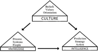
Based on the previous theoretical foundations, the Culture-Knowledge-Intelligence (CCI) model is constructed, which is shown in
Figure 1.
The premises of the CCI model are:
(i) Culture is formed by beliefs, values, assumptions and traditions of a society
| [27] | Schein, Edgar H. Organizational Culture and Leadership. San Francisco: Jossey-Bass Publishers. 1985. |
[27].
(ii) The central argument is that, for education to be successful in its tasks, the curriculum as its core must be restructured or reformulated around the four pillars of learning: learning to know, learning to do, learning to live together and learning to be
| [28] | Nao-Zhao, N., Pei, Y., Liang, Y., & Niyato, D. T. (2023). Multi-Agent Deep Reinforcement Learning Based Incentive Mechanism for Multi-Task Federated Edge Learning. IEEE Transactions on Vehicular Technology, 72, 13530-13535. |
[28].
(iii) The three pillars of intelligence are: prediction, strategy and action
| [25] | Rothberg, H. N. Erickson, G. S. “From Knowledge to Intelligence: Creating Competitive Advantage in the Next Economy”. 2004. |
[25].
Figure 1: The culture-knowledge-intelligence model (adapted from
| [26] | Choo, C. W. (2022) The Knowing Organisation, Oxford University Press, New York, NY. |
[26]
).
The model CCI is based on three hypothesis (
Table 1):
Figure 1. CKI model (own elaboration).
Table 1. Premises of CKI model.
Hypotheses | Sources | Results |
Cultural has a positive impact on Knowledge | Leidner et al. | [29] | Leidner, D. E., Alavi, M., & Kayworth, T. R. (2006). The Role of Culture in Knowledge Management: A Case Study of Two Global Firms. Int. J. e Collab., 2, 17-40. |
[29] | [31] | Tweed, R. G., & Lehman, D. R. (2002). Learning considered within a cultural context. Confucian and Socratic approaches. The American psychologist, 57 2, 89-99. |
[31] | SUPPORTED |
Cultural has a positive impact on intelligence | Culture, more than genetics, determines behavior and determines its actions | [24] | Kroeber, A. L. The Concept of Culture in Science. The Journal of General Education. Vol. 3, No. 3, pp. 182-196 (15 pages). Published By: Penn State University Press. 1949. |
[24] Umuteme et al. | [32] | Umutem, O. (2022). AN EVALUATION OF THE IMPACT OF LEADERSHIP AND CULTURE ON THE SUSTAINABLE DEVELOPMENT OF 21ST CENTURY ORGANIZATIONS. |
[32] | SUPPORTED |
Knowledge has a positive impact on intelligence | Rothberg and Erickson | [24] | Kroeber, A. L. The Concept of Culture in Science. The Journal of General Education. Vol. 3, No. 3, pp. 182-196 (15 pages). Published By: Penn State University Press. 1949. |
[24] | SUPPORTED |
The CCI model showed the relationship between culture, knowledge and intelligence. In the case of the Rio Grande do Sul flood, it was very clear that the culture of lack of planning (immediacy) and lack of investment in improvements that do not attract votes from the population had a strong impact on knowledge, in particular tacit knowledge (practical experience difficult to articulate and then share and therefore depends heavily on trust, engagement and social identity), on the means to reduce the damage caused by floods. Intelligence was also impacted by culture, as there was great difficulty in transforming the experience of some technicians and professor-researchers into concrete results before and after the moment of greatest need: the flooding of engine rooms and the passage of water over the dams. containment.
4- The transformation of tacit knowledge into explicit.
The importance of sharing tacit knowledge for practices to reduce illiteracy.
It is important to understand how socialization facilitates the search for tacit knowledge, from a perspective based on Knowledge Management - KM activities
| [33] | Schatzi TR, Knorr-Cetina K, von Savigny E (eds) (2001) The Practice turn in contemporary theory. Routledge, London. |
[33]
Specifically, Gubbins & Dooley
| [34] | Gubbins, C., & Dooley, L. Delineating the tacit knowledge‐seeking phase of knowledge sharing: The influence of relational social capital components. Human Resource Development Quarterly. 2021. |
[34]
consider social capital (the relational aspect rather than the cognitive and structural one) as an important precursor to tacit knowledge sharing, which in turn influences an organization's innovation capacity.
However, current research lacks empirical evidence supporting the relationship between interpersonal trust and knowledge acquisition
| [35] | Kucharska, W. Erickson, S. Tacit knowledge acquisition & sharing, and its influence on innovations: A Polish/US cross-country study, International Journal of Information Management, Volume 71, 2023. |
[35]
.
Although tacit knowledge is individually owned, difficult to articulate, imitate or replace
| [36] | Barney, J. B. Clark, D. N. Resource-Based Theory: Creating and Sustaining Competitive Advantage (Oxford, 2007; online edn, Oxford Academic, 31 Oct. 2023), |
[36]
, it can be shared by social relationships, but depends on the following points:
1) Ways in which types of relationships condition the flow of information and learning in networks
.
2) Knowledge transfer depends critically on trust
| [35] | Kucharska, W. Erickson, S. Tacit knowledge acquisition & sharing, and its influence on innovations: A Polish/US cross-country study, International Journal of Information Management, Volume 71, 2023. |
[35]
and therefore it is necessary to understand what types of trust are associated with the effectiveness of interpersonal knowledge transfer, however research produces on this topic produce inconclusive results
| [34] | Gubbins, C., & Dooley, L. Delineating the tacit knowledge‐seeking phase of knowledge sharing: The influence of relational social capital components. Human Resource Development Quarterly. 2021. |
[34]
.
3) There are phases prior to sharing, which are the basis for initiating sharing (Lee & Han, 2024), including the knowledge search phase
| [34] | Gubbins, C., & Dooley, L. Delineating the tacit knowledge‐seeking phase of knowledge sharing: The influence of relational social capital components. Human Resource Development Quarterly. 2021. |
[34]
.
Gubbins and Dooley
| [34] | Gubbins, C., & Dooley, L. Delineating the tacit knowledge‐seeking phase of knowledge sharing: The influence of relational social capital components. Human Resource Development Quarterly. 2021. |
[34]
found that social identity is more likely than trust to confer a greater sense of psychological safety for seeking tacit knowledge in groups. Therefore, it is essential to develop environments where individuals feel safe to ask and share.
The great difficulty in understanding tacit knowledge and transforming it into explicit knowledge is that people are very afraid to share what they know, either out of fear, even more so in times of pandemics and wars, or out of fear of losing their position.
Duan et al.
| [38] | Duan, Y., Huang, L., Cheng, H., Yang, L., & Ren, T. The moderating effect of cultural distance on the cross-border knowledge management and innovation quality of multinational corporations. Journal of Knowledge Management, 25(1), 85–116. 2021. |
[38]
state that a lot of knowledge is needed to learn about the reasons and consequences why people hide knowledge, Singh
| [39] | Singh, S. K. Territoriality, task performance, and workplace deviance: Empirical evidence on role of knowledge hiding. Journal of Business Research, 97, 10–19. 2019. |
[39]
recommended that future research examine how different dimensions of knowledge hiding, such as explicit and tacit knowledge hiding, influence organizational performance.
Overall, studies on the effect of hiding explicit and tacit knowledge on a company's innovation have been largely unexplored and this is very important for innovation, particularly in education, a topic full of challenges.
Shahzad, Chilba and Arslan
| [40] | Shahzad, F. Chilba, S. Arslan, A. Tacit knowledge exchange among senior management educators: A qualitative study, The International Journal of Management Education, Volume 22, Issue 2, 2024, |
[40]
show that explicit knowledge transfer has a great impact on innovation. A more codified and formal presentation of knowledge has proven to be an effective way of transferring knowledge and supports the argument for using resources such as manuals and written guides in the knowledge transfer process. However, tacit knowledge transfer has not been found to have a significant direct effect on innovation.
The need to transform the tacit knowledge of participants in government social participation initiatives is therefore clear. And also from public administrators and managers themselves. This study aims to examine the underlying process through which the culture of the learning organization positively influences knowledge sharing to improve collective knowledge collection and use with a focus on improving the effectiveness of Brazilian public policies. To this end, it is essential to facilitate the sharing of knowledge through well-structured networks. Encouraging collaborative approaches and creating platforms for exchanging information can improve network-based learning. Therefore, this study suggests the integration of Knowledge Management and Organizational Intelligence practices.
Generating innovation based on tacit knowledge is a challenge
| [41] | Chesbrough, H. W., Teece, D. J., When is virtual virtuous? Organizing for innovation. Harv. Bus. Rev. 74(1), 65–73. 1996. |
[41]
due to the lower accessibility and lack of codification of this branch of knowledge.
The issue of culture is a key point in this process of transforming experience (tacit) into something written (explicit).
Lee and Han
| [42] | Lee, S. and Han, S.-h. "Learning organization culture and knowledge sharing: the mediating role of social capital", Journal of Workplace Learning, Vol. 36 No. 8, pp. 770-787. 2024. https://doi.org/10.1108/JWL-06-2024-0120 |
[42]
highlight that learning organizational culture is crucial for developing social capital within an organization. By promoting an environment that prioritizes continuous learning and development, organizations can promote adaptation, innovation and resilience
| [43] | Coleman, J. S. Foundations of Social Theory. Harvard University Press, Cambridge, MA. 1994. |
[43]
. When an organization cultivates a learning culture, it inherently encourages an atmosphere of support and collaboration. In such a culture, employees are more inclined to share knowledge, ideas and feedback, building trust and mutual respect among colleagues
| [44] | Maioli, S. C. Delan Devakumar, Shoshana Berenzon Gorn, Rochelle A. Burgess (2024). Growing up in transit. Personal development and resistance of migrant adolescents travelling through Mexico unaccompanied, Journal of Migration and Health, Volume 10. |
[44]
, placing special emphasis on the mediating role of social capital between the learning organization's culture and knowledge sharing
| [42] | Lee, S. and Han, S.-h. "Learning organization culture and knowledge sharing: the mediating role of social capital", Journal of Workplace Learning, Vol. 36 No. 8, pp. 770-787. 2024. https://doi.org/10.1108/JWL-06-2024-0120 |
[42]
.
Mohammed and Kamalanabhan
| [45] | Mohammed, N. and Kamalanabhan, T. J. (2022), "Tacit knowledge sharing and creative performance: a transformative learning perspective", Development and Learning in Organizations, Vol. 36 No. 4, pp. 5-8. https://doi.org/10.1108/DLO-09-2021-0161 |
[45]
highlight that tacit knowledge embedded in human minds in the form of work-related ideas, know-how and experience is difficult to codify and communicate. However, promoting a culture of shared responsibility for problems and social interactions can improve the tacit sharing of knowledge among employees. Several organizations have invested in collaborative virtual platforms considering their potential in promoting the sharing of specialized knowledge, allowing interactions between people.
Van Hounten
highlights that although personal knowledge is difficult to share accurately, it can be shared in a very appropriate and contextual way, using reflection and stories in which metaphors and examples convey personal knowledge. Such sharing can support others in their learning and practice: developing and applying new knowledge, ideas and techniques can help professionals change their behavior, such as communication, which can improve performance and practice. Therefore, the most direct answer would be: professionals can impact knowledge sharing and learning in the workplace by interactively and reflectively sharing and discussing stories, reflections, analyzes and experiences with others.
2.3. Knowledge Management and Communities of Practice
Knowledge Management is an attempt by organizations to capture, codify, organize and redistribute the organization's tacit forms of knowledge and make them explicit
| [25] | Rothberg, H. N. Erickson, G. S. “From Knowledge to Intelligence: Creating Competitive Advantage in the Next Economy”. 2004. |
[25]
The most effective practice of KM for creating a Hydrodinamic model is Communities of Practice – CoPs.
Three elements must be present in a CoP: domain, community and practice (a) Domain, a CoP presents an identity defined by a shared set of interests, committed members who share skills, learn from each other, stand out and are valued by this collective competition, not just a club of friends; (b) Community, participation in a one of the results of these communities of practice is cultural change. At this point, it is important to highlight three major challenges: (i) The creation of a culture of knowledge exchange within and outside public administration for the co-creation and implementation of policies, programs, projects and activities; (ii) Motivate and facilitate concise and organized expression in online debate, use specialized intelligent tools and systems to transform information into knowledge (contextualization) and wisdom (application). Recognition of the importance of the active participation of citizens, the private sector and public officials to create new knowledge, as well as intelligent systems and experts to facilitate/guide collaboration and analyze this new knowledge generated.
The issue of cultural change strongly benefits an Emergency plan based on Knowledge Management practices (Communities of Practice) and Organizational Intelligence (analysis by experts in each thematic group).
Emergency plans must be based on the selection of proactive measures, both structural (e.g. hydraulic engineering works) and non-structural (e.g. public policies for transferring knowledge to society), which will reduce the potential loss of life and economic losses.
The US government's Flood Hazard Mapping and Dam Failures (FEMA) HAZUS software allows mitigation planners to use information about dam failures to estimate potential damage and perform cost-benefit analyzes for the highest population areas. vulnerable areas and then allows the development of infrastructure projects and rezoning efforts.
According to FEMA, 40% of companies do not reopen after being hit by a catastrophe; another 25% end up closing activities within a year.
Ângelo Fontana, president of CIC-VT and the Commercial and Industrial Association of Encantado (Aci-E), believes that a movement by society and governments is necessary to allow the installation of companies in new industrial areas in the region and in the state, which are less susceptible to disasters, with the streamlining of bureaucracy relating to licenses, registrations and other procedures that need to be in accordance with legislation. Another issue raised is the need to desilt the Taquari basin, a subject that has been discussed for forty years.
The difference that emergency plans - resilience and disaster mitigation - can make in the face of a climate and environmental event of great magnitude can mean not only mitigating damage, but enabling the company to be a point of support for the community of the population affected by catastrophes.
According to Rafael Goelzer, director of Market Relations and also director at the Federation of Commercial Associations of Rio Grande do Sul (Federasul), resilience actions, added to various initiatives to preserve the environment and combat global warming, represent 20% of the company's fixed expenses monthly, since the beginning.
Wendland et al.
| [47] | Wendland, M. (2021). Das Schulpraktikum (Praxissemester) aus Sicht der Lehramtsstudierenden. Analysen zur Wirksamkeit universitärer und schulischer Lerngelegenheiten. disserta. |
[47]
found that synthetic materials can be designed to increase the efficiency and sustainability of energy production, storage and use.
For example, advanced solar cells, batteries and efficient catalysts can help reduce current dependence on fossil fuels and mitigate climate change.
With regard to transport, in particular public transport which is responsible for a large emission of CO2, the production costs of green (renewable) hydrogen are still much higher than those of hydrogen obtained from fossil sources, which emit greenhouse gases. stove. However, according to studies and practices in this area, this cost tends to equal that of fossil fuels in the short term.
Green hydrogen is produced by electrolysis, and electricity comes from renewable energy sources, such as solar, wind, hydraulic, geothermal, tidal, among others. Renewable hydrogen can also be produced using biogas (instead of natural gas) or biochemical conversion of biomass, as long as it meets sustainability requirements.
The costs, those related to production costs, are still much higher than those of hydrogen obtained from fossil sources, which emit greenhouse gases.
2.4. The Biodynamic – Hydrodynamic Model
Hydrodynamic models are used in cases of flooding and flooding to predict the density of water near the spillway and create an ideal flood discharge plan.
An emergency plan depends on variability in hydraulic and hydrological properties, as hydraulic indicators are impacted by land use and then climate change.
This work suggests the following Communities of Practice for sharing knowledge and experiences to improve the decision-making process:
1) Agriculture and Climate Change
2) Hydrodynamic models and necessary data
3) Improved forecasting in cases of flooding
4) Emergency plans and relationship with the population
5) Electrical structures of machine rooms
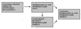
Based on this literature review, the relationship model between the Biodynamic Agriculture model and the Hydrodynamic Model is constructed:
Figure 2. Hydrodynamic model (own elaboration).
It is important to note in this model that the improvement of agricultural data has improved hydrological and hydrodynamic data given the relationship with climate change and even respect for the environment.