Abstract
Purpose: The study determined the factors that influenced Urban Land-Use zones compliance to integrated land use plan of Meru municipality in Meru County, Kenya. Methodology: The study collected data from. A sample of 389 residents from a population of 88,871 using Krejcie and Morgan formulae. Questionnaires, interviews, and observations were used to collect data from developers and key informants the data was sorted, processed, and analyzed using Microsoft Excel SPSS software to produce tables and graphs showing the various factors influencing land use zones compliance to integrated land use plan. Findings: The study identified ten factors that influenced land use zones compliance to LUP which included: corruption, desire to maximise profit on plots, high fees charged by the development professionals, ignorance, political interference, lack of adequate public awareness, high poverty levels, poor land use plan enforcement, historical factors and complexity of the land use plan regulations Unique contributor to policy and practice: This research is therefore beneficial to policy makers since it examines the effectiveness of land use plan in guiding spatial distribution of developments. It is vital in making future decisions by county governments who play pivotal role in spatial planning. The study is also beneficial to urban planners since it has given out spatial planning recommendations that are appropriate in modern society.
1. Introduction
Urban land use planning is critical in promoting sustainable development, particularly in rapidly urbanizing regions. In Meru Municipality, Kenya, the implementation of integrated land use plans is essential to ensure orderly development, efficient use of resources, and the provision of essential services. An integrated land use plan aims to harmonize various land uses such as residential, commercial, industrial, and recreational, considering the socio-economic and environmental dynamics of the area.
Evaluating the compliance of urban land use zones to the integrated land use plan in Meru Municipality is crucial for several reasons. It helps to identify whether the designated land uses are adhered to, ensures that development activities are in line with the overall vision for the municipality, and highlights areas where deviations might lead to issues such as congestion, environmental degradation, or socio-economic disparities.
According to Bagan
| [7] | Bagan, H., & Yamagata Y. (2015). Analysis of Urban Growth and Estimating Population Density Using Satellite Images of Night-time lights and Land -use and Population Data’. Journal of Humanities and Social Science pg. 765-780. |
[7]
, urban Land Use Plans (LUPS) play a crucial role in environmental control of urban landscapes by guiding the physical developments that take place on and in them. He noted that despite the crucial role played by the urban land use plan; there is a limited knowledge on the extent to which their mapped objectives are achieved in real situation. According to Razier
| [22] | Razier R., Naser B. (2015). Conformance -based and Performance -based Approaches of Implementation evaluation in Land-Use Planning, Case study: Conformance-based evaluation in city of Lavasan. Art University of Tehran. Reinvention 4-6 July, 2016, Sandton Conventional Centre. |
[22]
, plans are evaluated using three different criteria, namely; performance-based, conformance-based, and synthesis-based. This research dwelled on the conformance- based approach. Examining the degree of relationship between the results on the ground and the planned proposals on the land use plan is referred to as conformance-based evaluation. Until we evaluate the influence of plans after adoption on urban land use, planning will remain uncertain science. Despite the fact that land use plans are very important, conformance between proposed land use plan zones and the actual urban land use of need to be evaluated
.
According to Mario
| [13] | Mario, G., Bherer L., Simald L. (2020). The professionalisation of Public Participation. New yolk. |
[13]
, the first land use plan can be traced in Los Angeles in 1906, and the first zoning code was enacted in New York City with the building zones resolution in 1916. Land use planning, according to Baker
| [6] | Baker, M. (2014). Land -use Planning. In: Michalos A. C. (eds) Encyclopaedia of Quality of Life and Well -Being Research. Springer, Dordretch. |
[6]
, is a public policy intervention that involves the efficient, sustainable, and ethical ordering and management of land use. Razier, defines
| [22] | Razier R., Naser B. (2015). Conformance -based and Performance -based Approaches of Implementation evaluation in Land-Use Planning, Case study: Conformance-based evaluation in city of Lavasan. Art University of Tehran. Reinvention 4-6 July, 2016, Sandton Conventional Centre. |
[22]
it as the process by which developers, landowners, municipalities, and other stakeholders collaborate to approve a land-based project while adhering to policies that promote a positive environmental and social impact while allocating resources.
Land use plan can be defined in a myriad of ways, with the traditional definition emphasising planning as a systematic process aimed at managing future land use and development
| [11] | Hudalah, D. & Woltjer, P. (2007). Spatial Planning System in Transitional Indonesia. In International Planning Studies, Vol 12(3) pg. 290-305. |
[11]
. He notes that, land use planning makes sure that resources are used appropriately to meet people's needs while also ensuring sustainability of resources. When planning of land usage is done well, the local community benefits in terms of the ecological, social, physical, and economic situations. The goals of spatial planning include the following: Identify potential alternatives for land use, evaluating the untapped potential of land and water on the site, assessing local, social and economic conditions and sustainability, efficiency and equity of resource distribution.
Planning of land usage, gives a framework for the project development before it officially starts. The plan helps in anticipating the future of a certain location, enabling developers to construct infrastructure that mitigates future risk. The urban economy benefits from the land-use plan in coming up with measures to curb the effects of climate change. It promotes conservation of natural resources and enhances environmental protection. The plan prevents development in places prone to natural disasters; it prevents the environment from the negative consequences of transportation while reducing emissions and costs. It safeguards the public from health and safety associated risks and finally, it helps to avoid conflicts between land uses
| [23] | Republic of Kenya (2019). National and Urban Policy, Nairobi, Government Printers, Nairobi, Kenya. |
[23]
.
According to Owino
| [20] | Owino, O. Hayombe, O., & Agong’, G. (2014). Spatial Planning Interventions and their Implications on Conservation of Urban Green Spaces. Asian Journal of Applied Science and Engineering. |
[20]
, planning of land use can take place at many different scales, county, national and at a global scale. The spatial plans in China consist of national plans, urban plans and rural plans. There are three types of planning systems: plans on social economic development, region spatial plans and urban-rural plans. Each of the four administrative levels (national, provincial, prefecture, county and township) develops a social economic development plan according to the ministry of Land, Infrastructure, Transport and Tourism. However, the three spatial designs are fragmented, lacking consistency and disagreeing with one another, resulting in inefficiency and resource waste
Planning on space is crucial for achieving social-economic and environmental advantages, according to Pogacnik
| [21] | Pogacnik A. (1999). The state of Public Participation in Spatial Planning in European Union. Public Participation in Spatial Between Theory and Practice. University of Ljubljana, Faculty of Architecture, Slovenia. |
[21]
. This is accomplished through fostering more concrete and certain investment and development changes with guaranteed community benefits and encouraging smart land and natural resource usage for development. As a result, spatial planning is an important instrument for ensuring long-term growth and improving quality of life.
Poland's spatial planning is governed by the Ustawa Act of 23
rd March 2003 on spatial planning and development. The act lays down the groundwork for territorial self-government units and administrative authorities to develop spatial policies. It defines the scope of activities as well as development activities for these areas (Ustawa,
| [27] | Ustawa, P. (2003) Act of 27 March 2003 on planning and planning for spatial Planning. |
[27]
Territorial governments units are equivalent to County governments in Kenya which are involved in spatial planning.
Spatial planning in the United States is largely governed at the local level, including counties, municipalities, and neighbourhoods. Down to the local level, planning and zoning are quite different. Local municipalities in the United States are responsible for spatial planning
| [11] | Hudalah, D. & Woltjer, P. (2007). Spatial Planning System in Transitional Indonesia. In International Planning Studies, Vol 12(3) pg. 290-305. |
[11]
. The spatial planning done by the local government in U.S.A can be linked to the planning done by the county government in Kenya. This study shall link the spatial planning in US with what happens in Kenya, and particularly, at the county level. It shall seek to find out whether local communities are involved in spatial planning.
According to the National Development and Planning Commission of South Africa NDPC)
| [25] | Republic of South Africa (1999). National Development and Planning Commission of South Africa. Cape town. |
[25]
, spatial planning is important because it gives direction and assessment of what is desired and all the possible spatial outcomes. It ensures that limited resources are used for maximum social and economic benefits. It ensures further all spheres of government offer high quality services and also upholds the right of the people through access to land and also ensures the natural systems are protected.
The 2019 Urban Planning in Kenya report noted that, planning processes have mostly failed, with so many haphazard developments, poor housing and infrastructure, environmental pollution and unimplemented laws and policies, besides other difficulties. Devolution allows planning to play a bigger role in growth. Planning is prescribed as an important function in development planning by the Urban Areas and Cities Act, Kenya 2010 Constitution and the County Governments Act. The planned development role was not evaluated during the first cycle of devolution (UN, Habitat,
| [1] | African Planning Association (APA) (2013). The State of Planning in African-Habitat HS Number: HS/010/14E. www.unhabitat.org |
[1]
) hence the need to carry out the evaluation of the plans. There are three basic approaches to urban development planning used by counties according to urban planning in Kenya
| [23] | Republic of Kenya (2019). National and Urban Policy, Nairobi, Government Printers, Nairobi, Kenya. |
[23]
. The approaches include the following: Urban Development Plans (UDP), Zoning Integrated Plans (ZIP) and Local Physical Development Plans (LPDP).
Despite the enormous resources devoted to developing Urban Development Plans in the counties, most of them have remained unimplemented for long, according to the report. Officers in charge of planning and political leaders have little concern for it
| [23] | Republic of Kenya (2019). National and Urban Policy, Nairobi, Government Printers, Nairobi, Kenya. |
[23]
. This could be attributed to the fact that earlier planning practices had little impact on influencing a desired goal, because work activities that are considered concrete, such as infrastructure construction, are given precedence. It was also mentioned by Baker
| [6] | Baker, M. (2014). Land -use Planning. In: Michalos A. C. (eds) Encyclopaedia of Quality of Life and Well -Being Research. Springer, Dordretch. |
[6]
that county planning offices at the county level lack adequate resources both monetary and technical, for effective implementation of the local plan.
The population of Meru municipality has been growing steadily. In the year 2009, the population was 67,888 and was projected to grow to 81,852 by the year 2018. The projection for 2020 was 85,289 and 2022 projections stood at 88,871, according to the report of Kenya national bureau of statistics of 2009. This shows a general increase in population of around 30.9% from the year 2009 to the year 2022. According to 2019 Kenya population and housing census, the population of Meru municipality stood at 80,191. This tremendous increase in population requires careful planning hence the need to evaluate whether the available land use plans conform to the land use activities on the ground
| [24] | Republic of Kenya (2019). Kenya Population and Housing Census, Nairobi, Government Printers. |
[24]
.
2. Literature Review
According to Dambeebo
| [8] | Dambeebo D. & Chernor A. (2018). Sustainable Urban Development and Land Use Management: Wa Municipality, Ghana. |
[8]
, in his study in Wa Municipality in Ghana, land use planning is one of the ways of attaining sustainable development especially in urban areas. He noted that government agencies are entrusted with the responsibility of enforcing the land use plans within their jurisdictions. The study identified weak enforcement, lack of institutional capacity and lack of public awareness coupled with landlord’s ignorance as the major factors behind noncompliance to urban regulations.
Yachori
| [28] | Yachori, B. (2017). Urban planning capacity development’s response to emerging issues of urbanization in the Wa and Lawra townships of Upper West Region. University for Development Studies. |
[28]
in his study in Ghana observed that most developing countries in the world have failed to implement their plans due to over-ambitious plans. According to a study by Osumanu
| [19] | Osumanu, I. K., Kosoe, E. A., & Dapilah, F. (2016). Residential housing in Ghana’s low-income urban areas: An analysis of households living conditions in the Wa Municipality. Journal of Geography and Regional Planning, 9(7), 139-153. |
[19]
in Wa Municipality in Ghana, increased quest for houses had made landlords to disregard planning regulations. He noted that development plans were not effectively supervised therefore development was not in line with the land use plan.
Akola
| [2] | Akola, J. (2007). Urban Planning as a Tool of Environmental Management in Kamwenge Town-Western Uganda. Master’s Programme in Urban Management and Development (October 2006 – September 2007). |
[2]
in his study in Kampala in Uganda found out that most of the problems experienced in Uganda towns were due to lack of enforcement of existing land use plans. Further Aluko
| [3] | Aluko, O. (2011). Development Control in Lagos State: An Assessment of Public Compliance to Space Standards for Urban Development. International Multidisciplinary Journal, Ethiopia. Indexed African Journals, 5(5), 169-184. |
[3]
observed that in Lagos, Nigeria there is a problem of creating balanced land use zones that reduce the conflict among the various land use zones. Similar sentiments were made by Fusieni
| [9] | Fusieni, I (2016). Urban governance and spatial planning for sustainable urban development in Tamale, Ghana. Stellenbosch University. |
[9]
who noted that in Ghana, open spaces and conservation zones were being invaded by human activities which pose a major ecological challenge.
In addition, lack of competence to audit and monitor development plans, as well as a lack of essential supported structures and resources by local governments, were major limitations impeding the spatial plan's efficacy (Musungu,
| [15] | Musungu, T. & Kimani, M (2010). Sustainable Urbanisation in Nyeri Town, Kenya. University of Nairobi. |
[15]
). Additionally, lack authorized physical development plans causes a problem of a lack of a uniform development control instrument. Professionals such as architect, engineers, planners and land surveyors charge very high fees which many town developers cannot afford (AAK
| [4] | Architectural Association of Kenya. (2019): A Study on Development Control Framework in Kenya, AAK Nairobi. |
[4]
, Opiyo,
| [18] | Opiyo & Omollo, (2020). Appraisal of Compliance with Land Subdivision Planning Regulations in Residential Neighbourhoods. International Journal of Human Capital in Urban Management., 5(2): 125-128. |
[18]
). This discourages the developers in engaging those professionals. Ngetich
| [17] | Ngetich J., Opata G. & Mulongo L. (2016). Making Urban Planning and Development Control Instruments work for Kenya Cities: the case of the city of Eldoret. Kenya. |
[17]
points out that with growing poverty levels in developing countries reaching as high as 50% of Kenya's urban population, compliance may not be a priority. Lack of awareness of the existence of land use control regulations’ considerable majority of the urban population is unaware of development laws; according to Kihato
| [12] | Kihato M. & Beresford S. (2006). The Role of Planning Law in evictions in Sub-Saharan Africa. Cape Town. |
[12]
as a result the set development control regulations are not being followed.
Architectural association of Kenya (AAK)
| [4] | Architectural Association of Kenya. (2019): A Study on Development Control Framework in Kenya, AAK Nairobi. |
[4]
noted that around 82 % of all the counties in Kenya do not have adequate development control staff. Those in charge are not able to supervise all the developments within their areas of jurisdiction. Political interference and lack of political good will have influenced plans implementation negatively. Ngetich
| [17] | Ngetich J., Opata G. & Mulongo L. (2016). Making Urban Planning and Development Control Instruments work for Kenya Cities: the case of the city of Eldoret. Kenya. |
[17]
points out that in the past, prominent government officials were known to enforce approvals that did not match the required standards. This has had a negative impact on planning. According to Ngetich
| [17] | Ngetich J., Opata G. & Mulongo L. (2016). Making Urban Planning and Development Control Instruments work for Kenya Cities: the case of the city of Eldoret. Kenya. |
[17]
, several planning policies and standards, such as the development control code and the construction and zoning regulations, are overly static and rigid. This renders them impractical, particularly in congested metropolitan environments. However, Barasa
| [5] | Barasa W. (2004). Land Use Planning Regulations and its Implications on Urban Land Use. Case Study. Umoja Phase One Estate. University of Nairobi. |
[5]
noted that development permission from relevant authorities plays a key role in compliance or noncompliance. According to his study findings in Umoja phase one, only 22% of the sampled residents were granted permission to develop while 78% were denied permission. The urge to maximise the returns by the developers had made them to violate some building regulations.
3. Materials and Methods
3.1. Study Area
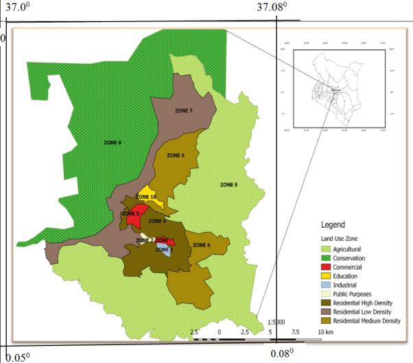
The study was conducted in Meru Municipality, Meru County, Kenya. The town is located in between longitudes 37.000 to 37.080 and latitude 0.0500 to 0.0700 on the Northern slopes of Mount Kenya. The Kathita River passes adjacent to the town. Meru town is situated about 8 km north of the equator, at an altitude of about 1500 m above sea level. It is located within North Imenti subcounty with the major ethnic group being the Ameru. The distance between Nairobi and Meru via Embu is about 224 km which is approximately 4 hours 30 minutes’ drive. It is the seventh largest urban centre in Kenya.
Figure 1. Spatial Location of Meru Municipality.
3.2. Data Collection and Analysis
Primary data was collected by structured questionnaires from respondents. Oral interviews were used to extract data from other respondents who needed assistance. Key informants’ interviews were used to collect data from physical planning offices of Meru County, County Director of Nema, town administrator and public works offices. Observation was a key instrument to ascertain the data collected through questionnaires and interviews. Data was also be collected through examining relevant documents and materials which might be difficult to obtain from the field such as land use planning regulations of Meru municipality and possible intervention measures for effective control strategies. Different checklists were used in different land use zones as stipulated in Meru County land use development regulations.
Data analysis started with data cleaning which involved identifying incomplete or inaccurate responses and correcting them to improve the quality of the responses. This was done after the questionnaires were collected from the respondents. Incomplete questionnaires were returned back to the respondents for completion. After editing the data, it was keyed in for analysis by the SPSS and Excel.
4. Presentation and Discussion of Results
4.1. Presentation of Results
The study was interested in finding out the factors that influenced land use compliance to land use regulations. The findings are presented on
Table 1.
Table 1. Factors Influencing Land Use Compliance to LUP Regulations.
Factors Influencing Compliance | % Contribution to Non-Compliance (According to Developers) |
Corruption | 23.2 |
Desire to maximize profit on plots/land | 20.2 |
High Fees Charged by development professionals | 17.3 |
Ignorance | 13.0 |
Political Interference | 8.7 |
Lack of Enough public awareness | 7.2 |
High poverty levels | 4.3 |
Poor land use plan enforcement | 2.9 |
Historical factors | 1.6 |
Complexity of the land use plan Regulations | 1.6 |
Total | 100. |
4.2. Discussion of Results
The study identified ten main factors behind land use non-compliance. The factors include; corruption, desire to maximize returns on the plots, high fees charged by the development professionals, ignorance, political interference, lack of public awareness, high poverty levels, poor land use plan enforcement, historical factors, and complexity of the land use plan regulations.
According to developers, corruption contributed 23.2% to non-compliance. The findings of this study mirrors with Wathome’s
| [26] | Wathome, E. M (2016). Analysis of Development Control Regulations’ Compliance Kitengela Town, Kajiando County, Kenya. |
[26]
findings in Kitengela town where he found that corruption contributed 22.5% to non-compliance of land use regulations. The study found out that corruption made the planning officials to allow developments which did not follow the planning regulations within the municipality. The developers were granted development proposals approvals without following the specifications of the land use plan. In return, the developers gave out different amount of money as bribes to planning officials. Corruption cases were identified with the political class who failed to adhere to the laid down land use plans since they believed they were shielded by the planning officials.
Developers (20.2%) cited desire to maximize profit on their plot as the second major factor behind non- compliance to land use plan. The study found out that the developers developed their plots maximally in order to get more returns from their plots. As a result of this, they violated the planning regulations such as the plot ratio thereby causing congestion within the plots. The residential areas lacked parking places within the plots making the tenants to park along the roads causing traffic jams within the towns. AAK
| [4] | Architectural Association of Kenya. (2019): A Study on Development Control Framework in Kenya, AAK Nairobi. |
[4]
also noted that increased demand for residential units has made developers to violate the land use planning regulations in quest to increase their returns on their plots.
High fees charged by development professionals contributed to non-compliance according to 17.3 % of the developers. The study ranked it as the third factor besides corruption and desire to maximize returns on the plot. The study findings differ with Wathome’s
| [26] | Wathome, E. M (2016). Analysis of Development Control Regulations’ Compliance Kitengela Town, Kajiando County, Kenya. |
[26]
findings in in his study in Kitengela, Kajiando county who noted it as the leading factor behind to non -compliance. To prepare development proposals, one requires services from the architects, structural engineers, physical planners, and environmental experts such as NEMA officials among other planning officials. All these professionals need to be paid for their services. The fees charged may be high making the developers overlook the land use regulations, in their development endeavours. This results in the violation of land use plan regulations.
The study found out that ignorance contributed to non-compliance to land use development control regulations as indicated by 13% of the respondents. Even though some developers had enough knowledge about the existence of land use plan regulations they choose not to follow them. The study found out that the leaders majorly contributed to this factor. The leaders believed that they were shielded hence there was no action that would be taken against them making them to violate the land use plan regulations. Ngetich
| [17] | Ngetich J., Opata G. & Mulongo L. (2016). Making Urban Planning and Development Control Instruments work for Kenya Cities: the case of the city of Eldoret. Kenya. |
[17]
, noted that impunity may arise when the developers are not aware of the effects of non-compliance.
The study found out that political interference contributed 8.7% to non-compliance. It was found out that some of the developments done in conservation zones; for instance, the designated wetlands belonged to prominent politicians within the county. These politicians were shielded by the leaders hence the planning officials may not be able to take legal action against them. This leads to perpetual non-compliance to land use plan regulations. The study also found that the county government of the day may not take legal action against some illegal developments within the municipality since they belong to some of their friends. It was noted that those officials who were strict in monitoring the plans were transferred to other departments to prevent them from monitoring the plans.
The study noted that lack of public awareness contributed to non-compliance as indicated by 7.2% of the respondents. For a developer to comply he/she must be aware of the land use plan and its content. Mugambi
| [14] | Mugambi, P. (2013). County Integrated Development Plan 2013/2017: Meru County pg. 41-43. |
[14]
, notes that people cannot comply with regulations if they do not know what is required of them. Wathome
| [26] | Wathome, E. M (2016). Analysis of Development Control Regulations’ Compliance Kitengela Town, Kajiando County, Kenya. |
[26]
observed that 7.5% of the developers cited lack of public awareness as factor behind non-compliance to land use plan. This study found out that lack of enough public sensitization is a factor that has contributed to lack of public awareness. Lack of enough public awareness has been caused by lack of financial and enough human resources to facilitate public barazas and seminars and other avenues of disseminating the information (according to planning officials). Consequently, developers have violated land use plan because of lack of information about them.
Developers (4.3%) cited high poverty level as factor that has contributed to non- compliance. Poverty has made the developers not to afford to develop permitted structures by the land use plan. This has made them to opt for simple semi- permanent structures across all the land use zones. Majority of the semi- permanent structures like the garages and timber yards had no approved development proposals. Most of the developments were mainly guided by the developers’ sketches which did not follow the laid down planning regulations. Poverty determines the compliance level especially in residential areas for low-income earners according (UN Habitat International,
| [1] | African Planning Association (APA) (2013). The State of Planning in African-Habitat HS Number: HS/010/14E. www.unhabitat.org |
[1]
).
Developers (2.9%) and the planning officials (100%) interviewed cited poor land use enforcement as a contributor to non-compliance to land use plan. Kimani and Musungu
| [16] | Mugo N., Kuria N. & Mubea, K. Assessing the Compliance of Physical Plan using GIS &Remote Sensing. International Journal of Science and Research (IJSR) 2014. 3(12). https://rimcl.dkut.ac.ke/publications/ |
[16]
identified poor supervision and inadequacy of financial and human resources as some of reasons for poor land use plan enforcement. This study also noted that there are few county officials to monitor the implementation of land use plan. The study also noted that some of the officials had no modern skills like GIS and remote sensing skills to monitor the land use plan. Most of the enforcement officials were employed when the municipal council plans were shaping developments within the municipality. The land use zones away from the central business district (CBD) were inadequately monitored since the few monitoring officials concentrated on the CBD. This resulted to non- compliance especially in the agricultural zone without being noticed due to inadequate regular inspections and supervisions of developments.
The study noted that historical factors contributed to 1.6% to non-compliance. According to observation and responses from developers, some of the developments were done long time ago before the introduction of the land use plan. They were guided by the municipal council plans which were prone to alternation any time the new municipal council came in. This is because the municipal councils were developing the towns with little emphasis on the plan. Mugo
| [16] | Mugo N., Kuria N. & Mubea, K. Assessing the Compliance of Physical Plan using GIS &Remote Sensing. International Journal of Science and Research (IJSR) 2014. 3(12). https://rimcl.dkut.ac.ke/publications/ |
[16]
in his study on assessment of compliance of physical plans using remote sensing in Olkalau town pointed out that municipal council physical plans were prune to alteration. Some of the residents in industrial area said that they were relocated to industrial zone after the former leaders grabbed their plots within the town. They said that they sought for any other available land within the municipality for settlement. This made them to occupy zones that are not in line with the land use plan.
Developers (1.6%) cited the complexity of the land use planning regulations as a factor behind non-compliance. The developers argued that development proposals are done by different departments such as public works, Nema, county physical and urban planning, National construction authority and public health departments. These departments are not linked hence delay in approving the development proposals. The delay discourages the developers making them to start the developments without the approvals hence violating the land use plans. According to architectural association of Kenya (AAK)
| [4] | Architectural Association of Kenya. (2019): A Study on Development Control Framework in Kenya, AAK Nairobi. |
[4]
, delays in the evaluation of land use plans result to developers developing without the approvals.
6. Recommendations
Meru Municipality to evaluate and revise its integrated land use plan on a regular basis to take into account shifting population demographics, urban development trends, and economic factors. By doing this, the strategy is kept current and practical.
In order to educate locals, property owners, and developers about the integrated land use plan, zoning laws, and the significance of compliance, the municipality to fund public awareness campaigns and educational initiatives. Stakeholders are more likely to willingly cooperate if they are informed.
To ensure public comprehension and accessibility of zoning laws, proposing a simplification and streamlining process is advisable. The implementation of straightforward and uncomplicated regulations can reduce confusion and minimize instances of non-compliance.
Improvement of enforcement procedures to guarantee that zoning ordinance infractions are quickly found and resolved. This can entail expanding the capabilities of the authorities in charge of enforcing the law, enacting penalties for noncompliance, and enhancing monitoring systems.